
Florida Winter 2026–27: Could a Historic El Niño Bring More Rain and Storms?
Last updated: November 12, 2026 · Forecast information checked November 12, 2026

Photo illustration based on an original Florida Home Vibes photograph taken along Veterans Expressway on November 10, 2026. Digitally enhanced with AI-assisted editing for editorial presentation; not evidence that this cloud formation was caused by El Niño.
Why forecasters are watching the Pacific, what past El Niño winters brought to Florida, and what the outlook means from Tampa Bay to the Keys.
Florida’s winter weather usually means fewer thunderstorms, comfortable afternoons and a welcome break from summer humidity. But this dry season may not be quite so dry.
A rapidly strengthening El Niño has changed the winter outlook for much of the southern United States. For Florida, NOAA’s October 15 forecast favors above-normal winter rainfall. Local National Weather Service offices are also highlighting a greater risk of organized thunderstorms and severe weather, especially as winter moves toward spring.
That does not mean every weekend will be rainy, that Florida is guaranteed a tornado outbreak, or that we are headed for months of freezing weather. Seasonal outlooks describe which outcomes are more likely, not what will happen on any particular day.
The Florida winter outlook, at a glance
- El Niño is underway and still strengthening. NOAA’s November 12 assessment said a strong-to-very-strong event remains likely through January–March 2027 (a greater than 79% chance).
- A wetter dry season is favored. The national winter outlook points toward above-normal rainfall in Florida from December through February.
- Severe storms deserve attention. Historical data from the Tampa Bay NWS office shows more than twice as many combined severe-weather events in very strong El Niño cool seasons than in other ENSO categories across its forecast area.
- A deep freeze is not the main forecast. Near-normal seasonal temperatures are favored for much of Florida, though individual cold snaps and inland freezes remain possible.
Sources: NOAA ENSO discussion, NOAA winter outlook, NWS Tampa Bay winter outlook.
First, what does El Niño actually do?
El Niño develops when surface waters in the tropical Pacific become unusually warm and the atmosphere responds. That change can influence the position and strength of the jet stream, the fast-moving ribbon of air that helps guide weather systems.
In a typical El Niño winter, the southern branch of the jet stream shifts farther south and becomes more active. That gives fronts and low-pressure systems a better chance of tracking across the Gulf Coast and Florida instead of passing well to the north.
The result is not one endless storm. Think more opportunities for rain, cloudy stretches and occasional strong weather systems, separated by perfectly pleasant Florida winter days. NWS Tampa Bay notes that cold fronts can move through the peninsula nearly weekly during El Niño patterns, but their impacts vary considerably.
How does 2026 compare with earlier big El Niños?
Here’s the part that makes this winter especially interesting: by late fall, the current event had already reached a level associated with some of the strongest episodes in the modern record.
NOAA tracks El Niño using the Relative Oceanic Niño Index (RONI), which compares Pacific ocean-temperature changes with broader tropical conditions. To make a fair comparison, the figures below all cover the same August–October three-month window, rather than comparing a developing 2026 event with the final peak of an earlier winter.
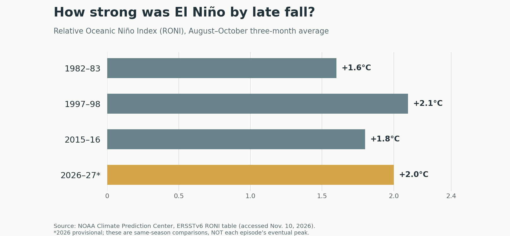
| El Niño winter | August–October RONI | Event’s eventual peak RONI |
|---|---|---|
| 1982–83 | +1.6°C | +2.4°C |
| 1997–98 | +2.1°C | +2.3°C |
| 2015–16 | +1.8°C | +2.3°C |
| 2026–27 | +2.0°C (provisional) | Not yet known |
The comparison does not guarantee that 2026–27 will finish as the strongest El Niño ever. But it explains why forecasters are paying so much attention.
In its November 12 discussion, NOAA put the chance of a historic event (a three-month RONI of +2.5°C or higher, above any El Niño since 1950) at about 60% for both October–December and November–January. That is still better-than-even odds, but lower than the 83% NOAA gave for October–December in its October 8 discussion. These are forecast probabilities, not an observed record. NOAA also reported that the Niño-3.4 index, a different measure from the RONI values above, had climbed to +2.5°C. Its next ENSO assessment is scheduled for December 10.
What Florida learned from 1998 and 2016
Looking back gives us a better sense of the possibilities, but it also shows why no two El Niño winters are identical.
1997–98: Extraordinary rainfall and a devastating tornado outbreak
From November 1997 through March 1998, the South Florida Water Management District reported 23.9 inches of rainfall, compared with a historical average of 11.7 inches for that period. That is more than twice normal rainfall across the district, not a statewide total. Source: SFWMD hydrology report.
That winter also brought one of the darkest chapters in Florida weather history. On the night of February 22–23, 1998, seven tornadoes struck Central Florida, killing 42 people and injuring more than 260. The storms affected communities including Winter Garden, Sanford and Kissimmee. The National Weather Service’s historical review describes how the strong El Niño-era jet stream contributed to an environment favorable for severe storms.
The lesson is awareness, not alarm: 1998 is an example of what can occur in a severe El Niño-season setup, not a forecast that the same disaster will happen again.
2015–16: Extreme winter rain and tornadoes closer to Tampa Bay
January 2016 was extraordinarily wet across South Florida. In its official post-event report, the South Florida Water Management District recorded an area-wide average of 9.18 inches for January, versus a historical average of 2.20 inches. That is a little over four times the average for that month in the district’s reporting area. Source: SFWMD after-action report.
The Tampa Bay region experienced dangerous weather too. On January 17, 2016, two EF2 tornadoes struck near Siesta Key/Sarasota and Duette in Manatee County. Two people died in the Duette tornado, WUSF reported. The NWS Tampa Bay event review connects the outbreak to a classic strong-El Niño severe-weather setup.
Last winter: A useful contrast
The winter of 2025–26 followed a La Niña pattern and was dry across much of West Central Florida. At Tampa’s official climate station, December-through-February rainfall totaled 5.91 inches, compared with a normal 7.83 inches. Brooksville recorded just 3.40 inches against a normal 8.14 inches. Source: NWS Tampa Bay winter 2025–26 summary.
That contrast helps explain why the prospect of a wetter winter matters now, especially in communities watching drought conditions and watering restrictions and water levels. But last winter’s observed totals should not be mistaken for predictions of how much rain any city will receive this winter.
So how much rain could Florida get this winter?
NOAA’s national winter outlook favors above-normal precipitation across Florida during December 2026–February 2027. That means the chance of finishing in the wetter-than-normal category is elevated. It does not mean forecasters can tell us the exact total for a street, a neighborhood or a county months ahead.
South Florida has a more specific regional estimate. In its November 3 dry-season outlook, the NWS Miami office cited a 60%–70% chance of above-normal rainfall from January through March 2027. It also found that past strong-to-very-strong El Niño episodes brought approximately 9–16 additional days of measurable rain during the South Florida dry season. Those are South Florida historical figures, not predictions of nine to sixteen extra rainy days everywhere in the state. Source: NWS Miami.
More rain could replenish streams, lakes and soil moisture after dry conditions. On the other hand, a few intense systems can also cause localized flooding, even during months Floridians normally think of as relatively dry.
The risk that deserves extra attention: Severe storms
Florida’s storm season doesn’t end when hurricane season ends.
According to an analysis of reports since the 1969–70 cool season, the NWS Tampa Bay forecast area has averaged more than twice as many combined tornado, severe-wind and severe-hail events in very strong El Niño seasons as in other ENSO categories. The statistic describes historical event reports across the entire forecast area, not a doubling of the chance that any individual home will experience a tornado. Source: NWS Tampa Bay.
Farther south, the NWS Miami office reports that El Niño dry seasons have produced 46% more tornadoes than La Niña dry seasons, and roughly twice as many strong-to-violent tornadoes rated F2/EF2 or higher. It says the expected very strong El Niño heightens the risk of severe weather, including tornadoes, through this dry season. Source: NWS Miami.
These findings are a reason to take winter watches and warnings seriously. They are not a way to predict the date, location or number of tornadoes this winter.
What about temperatures, cold fronts and freezes?
For much of Florida, NOAA currently favors near-normal average winter temperatures, not months of bitter cold. In West Central Florida, NWS records show that strong El Niño winters often begin with a near-normal to slightly warmer December, followed by cooler January and February averages.
That pattern can mean more cloudy, cool afternoons without unusually cold nights. An occasional freeze is still possible, particularly away from the coast and across the Nature Coast and inland Central Florida. The NWS cautions that the Arctic Oscillation, a separate atmospheric pattern that is difficult to predict many weeks ahead, often plays a larger role in Florida’s individual freeze events.
So while a few chilly mornings may arrive, El Niño alone is not a reliable forecast for snow, record cold or a major freeze. Sources: NOAA winter outlook; NWS Tampa Bay.
What it could mean where you live
Greater Tampa Bay, Pasco County and the Nature Coast: A wetter-than-normal winter is favored, with an increased opportunity for rain along passing fronts and occasional severe thunderstorms. Inland Pasco, Hernando and Citrus communities should still watch for cold snaps and freezes.
Central Florida and Orlando: More active winter storm tracks could bring widespread rain and occasional severe-weather episodes. The 1998 outbreak is a reminder that significant tornadoes can occur outside the familiar summer thunderstorm season.
Sarasota, Bradenton, Southwest Florida and the Gulf Coast: Watch for strong frontal storms, locally heavy rain and coastal impacts during individual low-pressure systems. Strong onshore winds can temporarily increase water levels along parts of the Gulf shoreline, bays and inlets.
North Florida and the Panhandle: An active southern storm track favors more opportunities for winter rainfall. These northern communities can also experience colder air behind fronts than South Florida.
South Florida and the Keys: The NWS Miami outlook favors a wetter, stormier dry season with a heightened severe-weather threat through the season. Temperatures are expected to average near normal over the season, although cloudy afternoons can feel cooler.
These are regional patterns, not city-by-city forecasts. The specific path of each front will matter much more when a storm is only days away.
Stay in the loop
Sign up to hear when we publish new blog posts and launch the full Florida Home Vibes website.
You'll get a short welcome email with an unsubscribe link. See our privacy policy for how signups are handled.
Five sensible things to do before winter storm season
- Keep emergency alerts turned on. Make sure your phone can receive Wireless Emergency Alerts and know where to find your local NWS forecast.
- Check drainage before heavy rain. Clear leaves and debris from gutters, downspouts and accessible drainage areas.
- Know your tornado-safe location. If a tornado warning is issued, move to a small interior room on the lowest floor of a sturdy building, away from windows.
- Secure loose outdoor items when storms approach. Patio umbrellas, decorations and lightweight furniture can be hazards in damaging winds.
- Have a plan for flooding and occasional cold. Never drive through flooded roads; protect sensitive plants and make arrangements for pets when freeze warnings are issued.
For real-time information, start with weather.gov and your county’s emergency management alerts. A seasonal outlook is useful for planning, but daily forecasts and official warnings are what guide decisions during an actual storm.
Frequently asked questions
Is El Niño already happening?
Yes. NOAA’s El Niño Advisory remains in effect, and its November 12 update said the event continued to strengthen. The question for winter 2026–27 is how strong it becomes and how its effects develop.
Will El Niño make Florida rain every day?
No. A wetter-than-normal seasonal forecast can still include long stretches of sunshine. It means the overall odds of above-normal rainfall are higher.
Does El Niño mean Florida will have a colder winter?
Not necessarily. NOAA favors near-normal seasonal temperatures across much of Florida. Individual cool spells and freezes are still possible, particularly inland.
Are tornadoes more common during strong El Niño winters?
Historically, yes, in parts of Florida. The NWS has documented elevated seasonal severe-weather activity, but no one can forecast a specific tornado outbreak months in advance.
Is a record-breaking El Niño guaranteed?
No. NOAA’s November 12 update put the chance of a historic event at about 60%, down from 83% in October, and the final peak has not yet been observed. NOAA’s next update is scheduled for December 10.
The bottom line
Florida’s winter of 2026–27 could feel different from the dry, quiet season many of us expect. The strongest signal is more opportunities for rain and organized storms, not a promise of nonstop bad weather or unusually cold temperatures.
The historical comparisons are worth paying attention to. But they should lead to preparedness, not panic. There will still be beautiful Florida winter days; the goal is to recognize when a passing front deserves a closer look.
Forecast information was checked November 12, 2026, using NOAA, National Weather Service and official historical reports. This article covers seasonal probabilities, not individual storm forecasts.
Sources & Further Reading
- NOAA Climate Prediction Center: ENSO Diagnostic Discussion (November 12, 2026)
- NOAA Climate Prediction Center: Historical Relative Oceanic Niño Index (RONI)
- NOAA: 2026–2027 U.S. Winter Outlook (October 15, 2026)
- National Weather Service Tampa Bay: Winter Outlook 2026–27 and ENSO’s Effect on Our Weather
- National Weather Service Miami: South Florida 2026–2027 Winter/Dry Season Outlook (November 3, 2026)
- South Florida Water Management District: 2011 South Florida Environmental Report, Chapter 2
- National Weather Service Melbourne: February 1998 Central Florida Tornado Outbreak, 20th Anniversary
- South Florida Water Management District: WCA-3A High Water Emergency After Action Report (July 2016)
- National Weather Service Tampa Bay: January 17, 2016 Tornado Outbreak
- WUSF: Tornado kills two in Manatee County (January 17, 2016)
- National Weather Service Tampa Bay: February 2026 and Winter 2025–26 Summary
- Florida Climate Center: El Niño on Pace to Be Strongest on Record (September 9, 2026)
- Related on Florida Home Vibes: Florida drought and water restrictions, 2026–2027
Florida Home Vibes follows the people, places and moments that shape life in Tampa Bay and Pasco County. Explore The Vibe Report for more local stories.
Explore The Vibe Report
Comments